
Region filter is extended with drawn areas
Regions in plaece.base allow you to easily group items (locations, events, etc.) within a geographical region. Combined with the region filter, your website visitors can view all entrepreneurs in a certain area. Until recently, we compiled the regions based on postcodes. From now on, it is also possible to set this based on a "drawn area on the map".
Area based on postal codes

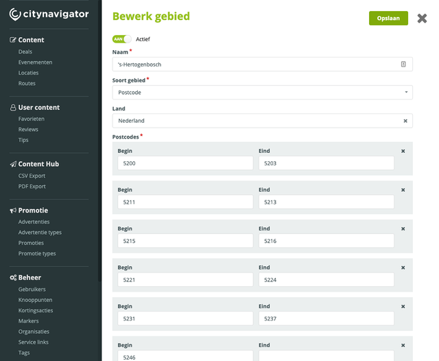
Example of 's-Hertogenbosch area based on postal codes
Setting up a city as an area means knowing all postcodes of that place in the plaece.base. If we look at a city like 's-Hertogenbosch, we need to enter the following postcodes:
5200, 5201, 5202, 5203, 5211, 5212, 5213, 5215, 5216, 5221, 5222, 5223, 5224, 5231, 5232, 5233, 5234, 5235, 5236, 5237, 5246
In plaece.base, we can enter all individual postcodes to an area or set a specific range. In the example above (the city of 's-Hertogenbosch), that would mean you get the following list:
5200 to 5203
5211 to 5213
5215 to 5216
5221 to 5224
5231 to 5237
5246
Especially for large (complex) areas, this can be a labour-intensive task. Fortunately, together we only have to do it once. But what if you have a small area, such as a square, park or nature reserve? Then you actually want to be able to set an area even more precisely. That is why we have now made it possible to draw an area on the map.
Area based on a drawn line

Example of National Park De Loonse en Drunense Duinen as an area
Supply us with a drawn area and we can import it into plaece.base. For example, use the following tool: https: //geojson.io. This allows you to draw an area on the map very precisely. Think for example of a park, nature reserve, neighbourhood or even an individual (shopping) street.
How it works (technical story ;-)
Every location or event stored in plaece.base comes with an address. That address can be traced back to a coordinate. For example:
Guldengaarde 4a, 5234 GG can be found at coordinates: 51.725173, 5.287658
We store this coordinate in plaece.base in the background. A drawn area consists of a lot of coordinates. e.g:

Based on the coordinates above, our search technology Elasticsearch can calculate which items fall within this area. For postcode areas, it works in a similar way. For each item with a postcode entered, it can calculate in which postcode areas the item falls.
You can do this with areas
Areas are one of the most powerful tools in the plaece.base. After all, you can filter your entire database on them.
Applications
Imagine: you have created a database of all the tourist information of the province of Utrecht (UBase). On the Amersfoort website, you only want to show all items from the city of Amersfoort (i.e. not from Woerden). For an item, you can specify on which application the item should be shown. An application can be filtered in the background for a specific area.
Region filter and sense of place

Example of a region filter on Visit Wadden
A practical example: you have a website for a large region such as the Wadden Islands. You want to offer visitors to the website the possibility to quickly view the offer of a specific Wadden Island. Then you can use the region filter.
And what about the ability to create landing pages for specific areas? Per page, you have the option to show only all locations of the selected area.
Drawn areas. Soon available in the region filter.
We make area drawing available free of charge to all partners using the region filter. So do you have a region filter on your website? Then we can now import drawn areas into plaece.base.
With the next update of plaece.base, we will make this functionality available automatically (and for free) to everyone with the region filter.